 |
|
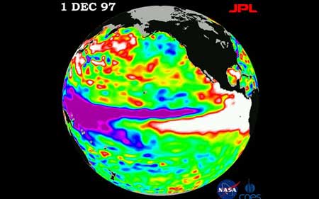
The World Meteorological Organisation (WMO) said its modelling suggested a "fairly large potential for an El Nino, most likely by the end of the second quarter of 2014" Photo: NASA |
|
The UN weather agency warned on Tuesday there was a good chance of an "El Nino" climate phenomenon in the Pacific Ocean this year, bringing droughts and heavy rainfall to the rest of the world. The World Meteorological Organisation (WMO) said its modelling suggested a "fairly large potential for an El Nino, most likely by the end of the second quarter of 2014". "If an El Nino event develops ... it will influence temperatures and precipitation and contribute to droughts or heavy rainfall in different regions of the world," Michel Jarraud, WMO chief, said in a statement. The El Nino phenomenon occurs every two to seven years, when the prevailing trade winds that circulate surface water in the tropical Pacific start to weaken. WMO pointed out Tuesday that since February, trade winds had weakened and there had been a significant warming of the waters below the surface in the central Pacific. "While there is no guarantee this situation will lead to an El Nino event, the longer the trade winds remain weakened, and subsurface temperatures stay significantly warmer than average, the higher the likelihood," it said. Two thirds of climate models predicted that the phenomenon would begin sometime between June and August, with a few suggesting it could start as early as May, and the remainder predicting no El Nino this year, it said. The last El Nino occurred between June 2009 and May 2010. It is often followed by a return swing of the pendulum with La Nina, which is characterised by unusually cool ocean surface temperatures in the central and eastern tropical Pacific. Scientists, who closely monitor the two climate patterns, say that while they are not caused by climate change, rising ocean temperatures caused by global warming may affect their intensity and frequency. "El Nino has an important warming effect on global average temperatures," Jarraud cautioned, stressing that combined with human-induced warming from greenhouse gases such events had "the potential to cause a dramatic rise in global mean temperature". |
據《每日電訊報》4月15日報道,聯合國氣象機構周二警告說,今年太平洋很有可能出現厄爾尼諾現象,給世界其他地區帶來干旱和暴雨天氣。 世界氣象組織(WMO )表示,該組織所建模型顯示2014年第二季度末之前極有可能出現厄爾尼諾現象。 “厄爾尼諾現象一旦出現……它會影響氣溫和降水,并會促成世界不同地區的干旱或大雨,”世界氣象組織秘書長米歇爾·雅羅在一份聲明中說。 每兩到七年,當環繞太平洋熱帶水域的盛行信風減弱時,就會出現厄爾尼諾現象。 本周二世界氣象組織指出,2月份以來,信風減弱了,而且太平洋中部水域表面下水溫變暖顯著。 聲明稱,“雖然也不能保證這種情況會導致厄爾尼諾現象,但是信風減弱時間越長,表面下水溫比常年變暖越顯著,出現厄爾尼諾現象的可能性就越高”。 三分之二的氣候模型預測這種現象將出現在今年六月至八月間,還有幾個顯示它可能在五月開始,而剩下的則預測沒有厄爾尼諾現象,該聲明說。 上一次出現厄爾尼諾現象是在2009年6月至2010年5月之間。 緊跟在厄爾尼諾現象之后的往往是拉尼娜現象的回轉,其特點是中部和東部熱帶太平洋表面溫度比正常溫度低。 密切監察這兩個氣候模式的科學家說,雖然它們不是由氣候變化所致,但全球變暖導致的海洋溫度的上升可能會影響其強度和頻率。 雅羅警告說,“厄爾尼諾對全球平均溫度變暖有重要影響”,他還強調說,加之溫室氣體排放引起的人為氣候變暖因素,這樣的現象“可能造成全球平均氣溫急劇上升” 。 (譯者 feilongmengjian 編輯 齊磊) 掃一掃,關注微博微信
  |